IMAGE: cass-titan-surfacedetails.jpg
IMAGE: cass-titan-surfacedetails.jpg
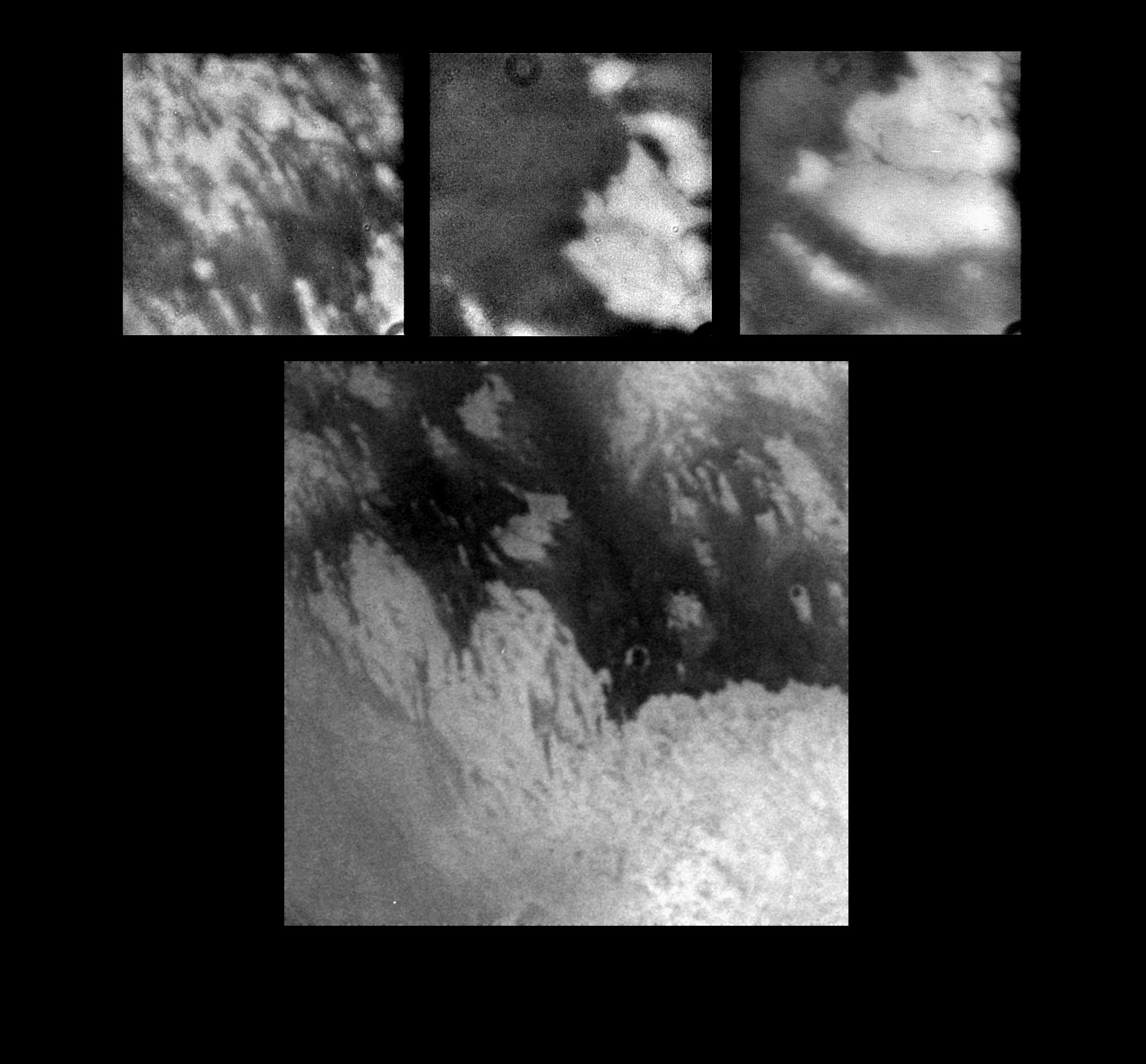
These images, taken during Cassini's first close flyby of Titan, show details never before seen on Titan's mysterious surface.
The large, bottom image shows a complex interplay between dark and bright material on Titan's surface. This image was taken at a range of about 340,000 kilometers (211,000 miles), and the entire view is approximately 2,000 kilometers (1,200 miles) across. The surface appears to have been shaped by multiple geologic processes. Although a few circular features can be seen, there are no features that can be definitively identified as impact craters. Cassini scientists are studying these and other images acquired during the flyby to understand the nature and origins of the intriguing features.
The three smaller images show details of some of the features seen within the larger scene. The image on the upper right shows a scene approximately 500 kilometers (311 miles) across in which bright and dark bands of material span east to west. The upper middle and upper right images show bright material surrounded by dark material in scenes approximately 300 kilometers (186 miles) across. Very narrow, dark bands can be seen crossing the bright terrain. These features are approximately 2 kilometers (1.2 mile) across and up to a few hundred kilometers long. The dark circular feature that appears at the top of each of the upper images is a camera artifact that was not removed by the preliminary image processing.
The tops of the images point to the northwest. The Sun is illuminating Titan from nearly behind the spacecraft, and there are no shadows or topographic shading visible in these images. All shading is due to surface brightness contrasts. The images were captured by Cassini's imaging science subsystem through near-infrared filters.
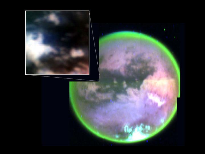
IMAGE: cass-titan-globe-haze.jpg
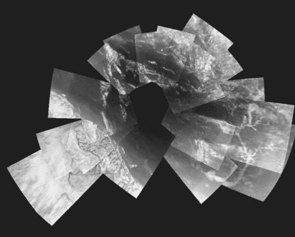
This image taken by Cassini's visual and infrared mapping spectrometer clearly shows surface features on Titan. It is a composite of false-color images taken at three infrared wavelengths: 2 microns (blue); 2.7 microns (red); and 5 microns (green). A methane cloud can be seen at the south pole (bottom of image). This picture was obtained as Cassini flew by Titan at altitudes ranging from 100,000 to 140,000 kilometers (88,000 to 63,000 miles), less than two hours before the spacecraft's closest approach. The inset picture shows the landing site of Cassini's piggybacked Huygens probe.
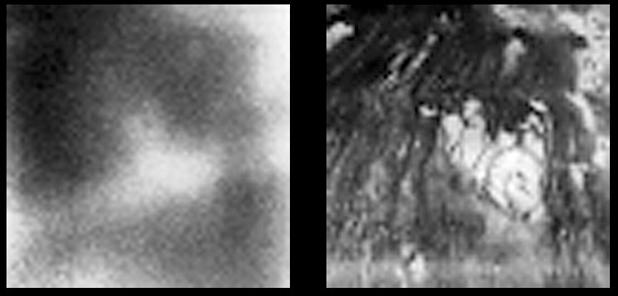
IMAGE: cass-titan-surface-hires.jpg
These images show the surface of Titan at two different infrared wavelengths. They were captured by the visual and infrared mapping spectrometer onboard Cassini as the spacecraft flew by at an altitude of 1200 kilometers (745 miles) - Cassini's closest approach yet to the hazy moon. The image on the right, taken at a wavelength of 2 microns, is the most detailed picture to date of the Titan's surface. It reveals complex landforms with sharp boundaries, which scientists are eager to further study. The image on the left was taken at a wavelength of 1 micron and shows approximately what a digital camera might see.
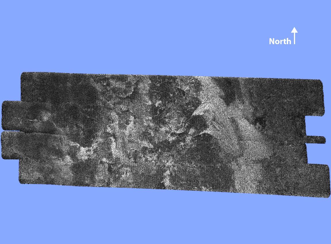
IMAGE: cass-titan-radar.jpg cass-titan-radar-sm.jpg
This radar image of the surface of Saturn's moon Titan was acquired on October 26, 2004, when the Cassini spacecraft flew approximately 1,200 kilometers (745 miles) above the surface and acquired radar data for the first time. It reveals a complex geologic surface thought to be composed of icy materials and hydrocarbons.
A wide variety of geologic terrain types can be seen on the image; brighter areas may correspond to rougher terrains and darker areas are thought to be smoother. A large dark circular feature is seen at the western (left) end of the image, but very few features resembling fresh impact craters are seen. This suggests that the surface is relatively young. Enigmatic sinuous bright linear features are visible, mainly cutting across dark areas.
The image is about 150 kilometers (93 miles) wide and 250 kilometers (155 miles) long, and is centered at 50 N, 82 W in the northern hemisphere of Titan, over a region that has not yet been imaged optically. The smallest details seen on the image are about 300 meters (984 feet) across.
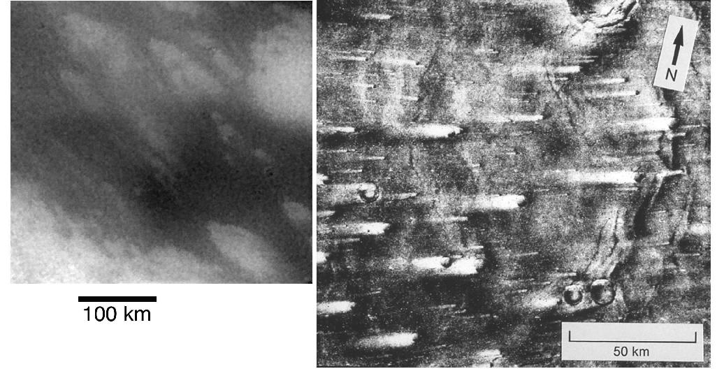
IMAGE: cass-titan-streaks-mars.jpg cass-titan-streaks-mars-sm.jpg
This image compares streaked terrain on Titan and Mars. At left is an image from Cassini of the region where the Huygens probe is expected to land. At right is a picture from NASA's Viking 1 orbiter, showing streaks on Mars caused by winds blowing from right to left. The streaks at the Huygens landing site were formed by some kind of fluid, possibly wind, moving from the upper left to lower right (west to east).
The Cassini image was taken on Oct. 26, 2004, by the spacecraft's imaging science subsystem using near-infrared filters. North is 45 degrees to the right of vertical. The scale of this image is 0.83 kilometers (.52 miles) per pixel.
OTHER:
N15/N14 is high (about 12), indicating lots of lost N14 over geologic time.
Complex hydrocarbons exist in upper atmosphere, including benzene, diacetylene.
This image is a combined and morphed composite of many images taken
during the descent, laid out like a map.
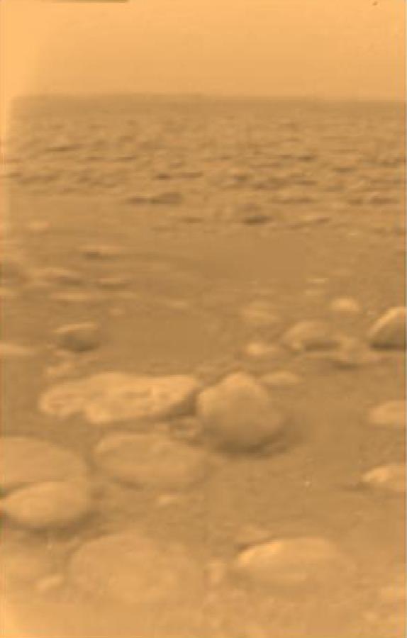
This image was returned January 14, 2005, by the European
Space Agency's Huygens probe upon its successful landing on
Titan. This is the colored view, following processing to add
reflection spectra data, and gives a better indication of the actual
color of the surface.
Initially thought to be rocks or ice blocks, they are more
pebble-sized. The two rock-like objects just below the middle of the
image are about 15 centimeters (about 6 inches) (left) and 4
centimeters (about 1.5 inches) (center) across respectively, at a
distance of about 85 centimeters (about 33 inches) from Huygens. The
surface is darker than originally expected, consisting of a mixture of
water and hydrocarbon ice. There is also evidence of erosion at the
base of these objects, indicating possible fluvial activity.
Jan 18: An international team of scientists continue to work hard on analysis of data sent back from Titan by the European Space Agency's Huygens probe. The team now believes the probe landed in mud. The latest details will be announced from ESA mission control on Friday at 2 a.m. PST.